Monday, June 6, 2022

Heading To Newfoundland! Our 2022 Adventure

 Hurray!  Tomorrow, we leave for a much anticipated trip through the Canadian Eastern Provinces, specifically to visit Newfoundland.  I guess Dick and I have a quest to visit far off, not quite as well known, vacation spots!  The motorhome is packed and the girls have had their "ready to travel" groom!


They've got their food, treats and grooming tools all packed and are ready to go! They are such good travelers, sleeping most of the way.

We're doing something we've never done before and that's traveling with an RV tour group.  There should be around 24 motorhomes in our group.  I always swore I'd never do this but, well, you know, you should never say never, right?  πŸ˜† After having spent a lot of time planning trips to Hawaii, and the Western US, I decided that simply writing a check and letting someone else do all the work was really the intelligent way to go!!

One thing that was really causing me a lot of anxiety was a 16 hour ferry trip from Newfoundland back to the Canadian mainland.  That meant that we would have to leave the dogs in our motorhome for all 16 hours, (we would not be able to visit them) while we bunked overnight in a cabin on board the ferry.  I know they would have stressed so much at not being able to go outside and having to relieve themselves in the motorhome.  BUT!!  GOOD NEWS!  Ferry crossing rules were just changed and they now have 8 pet cabins.  The gods were smiling on us as our wagonmaster was able to secure a pet cabin for us so Nika and Tisha will be able to stay in our room with us.  Best news I've had in months!

I am looking forward to seeing icebergs, whales, puffins, the Bay of Fundy and eating lobster! Just a quick word about the Bay of Fundy, it has the highest tides in the world, sometimes as much as 56'.  

This is a picture I took back in 2009 when the tide was out.  When the tide comes in all of this is underwater. The photo in my header was also taken in this area; those rocks you see, are mostly underwater when the tide is in.  It really is amazing.  


I hope you'll join me on my journey.  We're hitting the road at 7 am tomorrow!

Wednesday, July 31, 2019

Glaciers Everywhere!

Driving in northern Canada or Alaska is a visual feast of so many things, majestic mountains, fjords, pristine lakes, crystal clear streams, milky blue waters, and wilderness everywhere.   It's something I never get tired of!  On this trip we saw a lot of glaciers from various viewpoints making the whole experience quite interesting.

This is Bear Glacier on the road to Stewart, Canada and Hyder, Alaska.   It flows down to it's terminus into a lake that I assume was created by the glacial run-off.


This is a close-up of the glacier, you can see the water running out from under the ice.


Driving on past Fish Creek (the subject of my last post) you go back into Canada and up a dirt road for I don't know, maybe 15 - 20 miles you have a really great view of the Salmon Glacier.  What was so cool about this view is that you are looking down on the glacier as it rips through the valley.  

Look at the large crevass in the glacier and the blue color you see.  On the right is a body of water within the glacier.  I'm sure there's a scientific name for it and a great explanation that I do not know.  I just thought it was kinda cool!

Now on to beautiful Jasper and Banff.  These two beautiful Canadian National Parks are connected by the Ice Fields Parkway.  WOW, talk about fabulous views!  Along the way you pass the Columbia Ice Field that has several glaciers flowing down from it.  

We went on a fun tour that took us up onto the  Athabasca Glacier in an Ice Explorer bus.  We went down and of course back up, an 18% grade hill which is a 32ΒΊ angle.  The tires on that bus were gargantuan!


Yours truly 😊

And my sometimes better half!


It was kinda cool to walk around on the glacier and just a little bit chilly!


Will share more of the beauty of this area with you later.  Thanks for popping by.

Bear Viewing - Hyder, Alaska

Hyder is a very small Alaskan town that is completely surrounded by Canada.  It's a sleepy place that is dying.  When we were here in 2010 the population was around 73. now it is under 50.  Buildings that were standing in 2010 are now ruble.  Sad to see...

The road to Hyder is beautiful with glaciated mountain views. You are apt to see wildlife along the way and we did spot this Mama Bear and her adorable little cub along the road, they were just munching on grass and Mom was digging in the dirt, perhaps for grubs?  I don't know, maybe a tasty root?  What do I know, I'm not a bear.  πŸ˜ƒ


But, the big reason we go to Hyder is for the bear viewing at Fish Creek.  Below you can see part of the viewing boardwalk that is built along the creek.  Before the boardwalk was built, the locals told us they used to come and just sit near the creek bank and watch the bears.  The bears start showing up when the salmon return from the ocean to the creek of their birth to spawn and then die, starting a new salmon life cycle.  


Unfortunately, the salmon were a little on the late side and had just started returning to the creek so bear viewing was really slow. We only saw this one black bear and then just for a moment. He stripped some leaves from a bush and then ducked back in the bushes, re-emerging downstream just a little ways and only long enough for me to snap a few photos.


I love how he is holding his paw up checking out his surroundings.  One ranger thought perhaps he smelled a grizzly that had left scat nearby and decided to leave.  Black bears will defer to grizzlies.


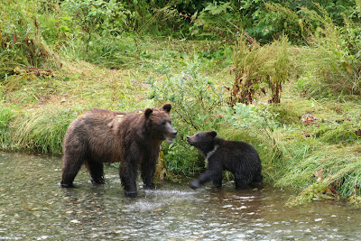
These are photos I took in 2010 of a grizzly mom and cub.  The cub was so cute trying to catch fish, he was not successful while we were watching.  Mom even caught a fish and gave it to the cub, but the fish got away from him.  These salmon were really big and can weigh as much as 50 lbs.  The cub played with dead fish while Mom caught dinner and shared it with him!


Chasing a salmon.

Thanks for joining us on our journey, next up, glacier viewing !

Thursday, July 25, 2019

Skagway -

Skagway is a coastal town in Alaska's southeast and it's notable for the part it played in the Klondike Gold Rush.  Many of the stampeder's came through Skagway on their way to the Klondike gold fields, over 600 miles away.  From Skagway they either went up the Chilkoot Trail (in nearby Dyea) or the White Pass Trail.  Both were arduous trails but the Chilkoot is famous for its nearly 45ΒΊ angle 3/4 mile climb to the summit of the pass.  It was so steep that stairs were carved into the ice that were known as the "Golden Stairs" and crossing this part was so difficult that many turned back at this point.  To make matters even worse, after they made the summit, the Canadian Mounties met them and required that they have 1 ton of supplies before being allowed to continue into Canada.  Now they have to go back to Skagway or Dyea and ferry their 2000 lbs of goods up that treacherous trail.  Those with money hired local native guides to carry their goods, everyone else made numerous trips up and down the trail.

That part of Skagway is fascinating and their are many relics and old buildings left from the gold rush days.  Otherwise Skagway is heavily visited by cruise ships.  The day we arrived there were 5 large cruise ships in port and we were told that's 12 - 13,000 people.  The town was wall to wall people to the point that walking was difficult.  Ugh, not for me. The next few days were much better and we did get to enjoy ourselves.  It is said that the cruise ships own Skagway now and it seems that way to me.  I noted a lot of jewelry stores that are also in the Caribbean ports that I have visited while cruising.

Though the cruise ships and all the people was a turn off, I recommend visiting Skagway just for the drive getting there.  It is such a pretty drive over rocky terrain that I think would look like the moon minus the green trees and shrubs.  There are alot of lakes along the way.  The pretty pink flowers you see in this photo are fireweed and grow everywhere and are said to be the first thing that comes back after a forest fire.


There is a narrow gauge train, The White Pass & Yukon, that goes from Skagway over the summit that is a great ride with breathtaking views.


 I included this photo because you can clearly see at least 3 glaciers, notice the blue coloring.

View of Skagway from a mountainside, note the cruise ships.


We did a fun city tour in these yellow buses.


Next stop, Hyder, Alaska, we'll be looking  for bears in Fish Creek, like this Mom and her cub that  I photoed in 2010.


Saturday, July 20, 2019

Reliving the Klondike Gold Rush

Dawson City in Canada's Yukon Territory, is famous as the site of the Klondike Gold Rush.  Gold was discovered there August 1896 and what ensued was pure mayhem!  An estimated 100,000 people tried to make their way to Dawson between 1896 and 1899.  Around 30,000 did make it to the Klondike gold fields but very few found their fortune in gold.  It's a fascinating bit of history that the US shares with Canada as many of the prospectors came from the lower 48.  Here's a Wikipedia link if you're curious to know more about it.  

For the next leg of our trip we will be visiting areas where the stampeders traveled to reach the Klondike.

Dawson City is on the banks of the Yukon River and the stern-wheeler was an important method of transportation.  Today the stern-wheelers are merely ghost ships abandoned along the banks of the Yukon.  This photo is from the stern-wheeler grave yard.  There are 7 ships abandoned there but this is the only on recognizable.  We were here in 1996 and I seem to remember that we saw 3 recognizable ship carcasses.


This is a stern-wheeler in Dawson City that has been preserved and  it is receiving a face lift in this photo.  


The Klondike Gold Rush lasted 3 short years and after that, most of the prospectors moved on, some to Nome, some returning home and some remaining in Dawson making their fortunes in the trades and mercantile businesses.

12 - 15 years later the gold dredges came to Dawson City and forever altered the landscape.  Gold dredges were behemoth machines designed to dig to bedrock and capture and separate gold from the bedrock.    The gold dredging operations lasted into the early 60's and then disappeared as gold mining was not economical.  At that time the price of gold was controlled and was just $35 oz.  Gold prices have since been deregulated and are currently at $1426.90 per ounce.

This is Gold Dredge # 4 outside Dawson City.  This is the largest dredge used in the Klondike and is one of about 24 used in the region.


The dredges left behind mounds of rock suitable for growing nothing and Dawson City's landscape illustrates the environmental ugliness left behind by the gold dredges.  Below are two photos of the landscape around Dawson City showing the mounds of bed rock left behind.  These rocks are known as tailings and they form snake like piles of rock all over the Dawson City/Klondike River area.


Aerial view of the tailing piles - these are the snakelike ribbons you see in this photo.


We visited Bear Creek Gold Camp which was a unit designed to support the dredges and perform the final refinement of  gold into gold bars.  Bear Creek is operated by the Canada Parks system and is fascinating as there are so many artifacts to see, everything from machinery to account books.

This photo was taken beside as very large machine shop and these trucks were part of the operation.  Of course, Dick loved the old trucks!


Another fun thing about Dawson City is that there is no bridge over the Yukon River and you have to take a ferry to continue your journey.  The ferry is free and runs all during the day and night.

If you are a fan of the TV show, Gold Rush, you might recognize the barge on the left in the photo below.  It belongs to Tony Beets and has been shown on the TV show.  The ferry is the vessel with the orange hull while the barge is pulled up on the shore.


Driving in Alaska & the Yukon

For the most part the roads have been good and we have encountered very little road construction as compared to all the construction we encountered in 1995 when we moved to Alaska.  At that time, they were still rebuilding sections of the Alaska Highway.  However, there is a section of road known as the Tok cutoff  and that road is AWFUL!!!  In places the road surface along the side is completely gone and the frost heaves are terrible.  Frost heaves occur when road is constructed over permafrost (permanently frozen ground).  The road surface attracts and holds heat, thereby causing the permafrost to melt, thus creating dips, waves and heaves in  the road surface. Trust me, you better slow down when going over these frost heaves!

Can you see the buckles in the road in this photo?  Those are frost heaves, SLOW DOWN!


This is a photo Dick took along the Klondike Highway.  The road is very narrow and there are no shoulders and wow, look at the drop off.  Yikes, better pay attention!  I was just hoping a moose or bear did not step out of the brush along the highway in front of us!!


On to Skagway, AK next where many of the gold rush prospectors entered Alaska on their way to the gold fields in Canada's Klondike.

Back to the Big City, Anchorage

We left Homer and drove back through the smoke to Anchorage and spent a few days being tourists.  We met up with the lovely Kathy Mosher and her hubby for lunch one day.  It was such a treat to finally meet Kathy as she's been an internet friend for a long time!

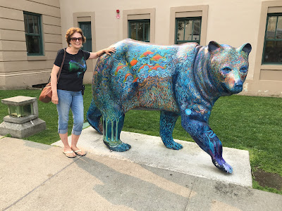
This is one bear I didn't mind getting close too.  Lots of neat art around Anchorage to see.

 This is the visitor's center in downtown Anchorage.  Notice that the roof is made of sod.  That's the way things were often done in the "old days" and even now I imagine for those that live off the grid.


 Prettiest flowers I've ever seen are in Alaska!

I love visiting zoos and that's where I captured this photo of the mighty eagle.  This guy was injured so he will live out his days in captivity being well cared for.


Next stop on the tour is Dawson City in the Yukon Territory famous as the site of the Klondike Gold Rush 1897 -1899.


Pictures around Homer

We were in Homer more than two weeks ago but I am just finding the time to post these photos. I'm way behind on blog posts, sorry.  Too busy having fun to sit at a computer! (Some were already of face book but I want to capture them all on this blog.)

Here I am bending my elbow in the Salty Dog Saloon.  It seems to have become a real tourist attraction but the first time I was here back in 1992 there were a lot of locals in the bar.  The walls are covered in dollar bills and some foreign currency from all over the world.  It's just what you do there, I don't know why.  There is a bell hanging at the bar with a rope hanging down to ring the bell.  Well DON'T RING the BELL!!  'Cause if you do, it means drinks all around for the bar on you!


In addition to all the money hanging from the walls and ceilings, there are articles of clothing: bras and panties.  It must get kinda crazy in there late at night!  


Time to go to church, now that we've been to the bar! πŸ˜ƒ This is a Russian Orthodox Church in Ninilchek.  There are a number of Russian Orthodox Churches in Alaska, remnants from when Russia owned Alaska.


I thought the cemetery was so pretty with all the wild flowers growing.

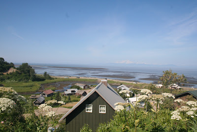
The church sits up on a bluff overlooking Cook Inlet and this is the view.  God's creation is amazing.


This quilt was hanging in the Wasilla Transportation Museum and was being raffled off.  I thought it was so pretty and well done!  The barn on the quilt is at the Museum and they are raising money to save the barn which is in need of some TLC.
 

We're about to head down the Cassiar Hwy in Canada and there are very few services along the way.  I'll be surprised if we have any internet service!  So I need to get busy and share some more photos with you!  Stay tuned...

As always, thanks for following along on our journey, we are having a great time!